| Scroll Ignore | ||||
|---|---|---|---|---|
|
https://www.youtube.com/watch?v=mpABt7pCGKo&list=PLt5jhPpkokeL7jZrgoINs1synCP7F3iAy&index=15
| Anchor | ||||
|---|---|---|---|---|
|
...
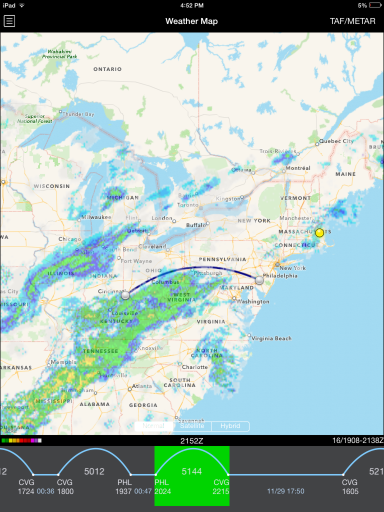
APDL offers a weather map to give you an overview of various things that you may encounter during your trip. The weather map displays an animated radar loop that can be overlaid over one of your flight segments, a timeline of your flight schedule, METAR and TAF data, and airport alerts.
| Anchor |
|---|
...
|
...
|
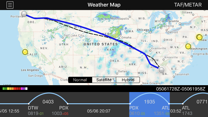
The map view retrieves NOAA radar data for the continental United States. The map view can be panned by dragging the screen and can be zoomed by pinching. The map is available in normal, satellite, and hybrid views. You can select one of these with the buttons at the bottom of the map view.
...
Radar loop details are displayed at the bottom right of the screen in the black bar. The date is shown first followed by a slash and then the beginning and end time of the currently displayed radar loop in Zulu. Current Zulu time is displayed in the center of the black bar for reference The radar imagery is updated automatically as new radar imagery becomes available from NOAA. Tapping the date on the black bar performs a manual check for new radar imagery.

| Anchor |
|---|
...
|
The Weather Map will display your route of flight when available. The ATC flight planned route is displayed as a dashed black line while the actual route of flight is displayed as a solid blue line. If the ATC flight planned route is not yet available for a future flight, a simple arc will be displayed as a dashed black line until the ATC flight planned route becomes available. This view is also available on the Status Board "Trip Route Map" widget.
| Anchor | ||||
|---|---|---|---|---|
|
The timeline at the bottom of the screen displays your scheduled flights in a linear form. Flights are displayed as an arc while straight lines indicate time on the ground.
...
The timeline can be scrolled left and right to view additional flights. Tap the "Today" calendar symbol button at the upper right to scroll back to the closest entry to the current date. The currently displayed flight is highlighted in green. Scroll any flight to the center of the screen to display it on the weather map. Alternatively, you can tap the timeline to select a different flight to display on the weather map. This will also cause the map to zoom to the route you have selected. Tap on the green highlighted area to open the Leg View for that flight.
...
| Note | ||
|---|---|---|
| ||
The overnight time displayed here is NOT the length of your rest per FAR 117. This only indicates time between flights. FAR 117 rest information is displayed on the Legality and Trip View pages. |
| Anchor |
|---|
...
|
...
The latest METAR and TAF data can be retrieved for any airport by tapping the weather symbol button at the top right of the screen. On iPad this button is labeled "TAF/METAR" while on iPhone 5S and smaller it is labeled "TAF" because of the reduced screen space available. The METAR and TAF function is exactly the same on both devices despite this difference..


Tapping this button opens a new window. At the top center of the new window, enter a 3 or 4 digit airport code. You can press the "Go" button on the keyboard or the refresh button at the top right of the new window to retrieve new data.
...
When displaying a flight segment in your schedule, each airport is represented by a dot. Tapping on the dot will display the identifier of the airport, brief METAR data, and a description of any Airport Alerts. Tapping the right arrow will open the full METAR and TAF view for that airport.

| Anchor |
|---|
...
|
...
|
Airports with FAA alerts will be displayed on the map with a colored dot. A yellow dot indicates a ground delay or departure delay while a red dot indicates a ground stop or airport closure. Tapping on these dots will also display the identifier of the airport, brief METAR data, and a description of the alert. Tapping the right arrow will open the full METAR and TAF view for that airport.
...