| Scroll Ignore | ||||
|---|---|---|---|---|
|
https://www.youtube.com/watch?v=mpABt7pCGKo&list=PLt5jhPpkokeL7jZrgoINs1synCP7F3iAy&index=15
| Anchor | ||||
|---|---|---|---|---|
|
...
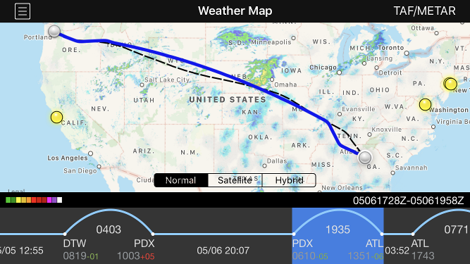
Radar loop details are displayed at the bottom right of the screen in the black bar. The date is shown first followed by a slash and then the beginning and end time of the currently displayed radar loop in Zulu. Current Zulu time is displayed in the center of the black bar for reference The radar imagery is updated automatically as new radar imagery becomes available from NOAA. Tapping the date on the black bar performs a manual check for new radar imagery.

| Anchor | ||||
|---|---|---|---|---|
|
The Weather Map will display your route of flight when available. The ATC flight planned route is displayed as a dashed black line while the actual route of flight is displayed as a solid blue line. If the ATC flight planned route is not yet available for a future flight, a simple arc will be displayed as a dashed black line until the ATC flight planned route becomes available. This view is also available on the Status Board "Trip Route Map" widget.
| Anchor | ||||
|---|---|---|---|---|
|
The timeline at the bottom of the screen displays your scheduled flights in a linear form. Flights are displayed as an arc while straight lines indicate time on the ground.
...
The timeline can be scrolled left and right to view additional flights. Tap the "Today" calendar symbol button at the upper right to scroll back to the closest entry to the current date. The currently displayed flight is highlighted in green. Scroll any flight to the center of the screen to display it on the weather map. Alternatively, you can tap the timeline to select a different flight to display on the weather map. This will also cause the map to zoom to the route you have selected. Tap on the green highlighted area to open the Leg View for that flight.
...
The latest METAR and TAF data can be retrieved for any airport by tapping the weather symbol button at the top right of the screen.


Tapping this button opens a new window. At the top center of the new window, enter a 3 or 4 digit airport code. You can press the "Go" button on the keyboard or the refresh button at the top right of the new window to retrieve new data.
...